The Aral Sea Divide: How Soviet Irrigation Drained a Sea and a Dam Revived the North
Soviet planners diverted the rivers feeding the Aral Sea to irrigate cotton fields, shrinking one of the world’s largest lakes into fragmented waters and a salt-laden desert that devastated fisheries, livelihoods, and public health. A dam has helped revive the smaller North Aral, but the much larger southern basin remains beyond restoration without water that surrounding agricultural economies still depend on. The story shows both the power of targeted repair and the lasting costs of treating downstream water as expendable.
By MyAudioBooks.ai ·
Listen free: The Aral Sea Divide: How Soviet Irrigation Drained a Sea and a Dam Revived the North
Outside the town of Muynak, in western Uzbekistan, commercial fishing trawlers sit upright in deep sand, their steel hulls rusted into ribbons. A generation ago, those vessels were tied to busy concrete docks, unloading sturgeon, carp, and bream into one of the largest fish-canning plants in Central Asia. Today, the water has retreated so far into the distance that the horizon is nothing but dry, salt-crusted earth. Within a single human lifetime, the Aral Sea lost more than ninety percent of its water, shrinking from the world's fourth-largest lake into fragmented puddles and a brand-new desert. The question is how an industrial power managed to drain an inland sea in pursuit of an agricultural vision. Even more puzzling is why, when engineers finally stepped in to undo the damage, only one half of the sea could be saved.
At My Audio Books dot A I, you can create your own audiobooks from prompts, turn your documents into audio, all with one subscription, and store your items in your own personal library.
To understand what was lost, you have to picture the geography of Central Asia in the middle of the twentieth century. Spread across the arid lowlands between present-day Kazakhstan and Uzbekistan lay a body of water covering roughly sixty-eight thousand square kilometers. By surface area, the Aral Sea was surpassed on earth only by the Caspian Sea, Lake Superior, and Lake Victoria. It was an inland expanse so vast that standing on its southern shore gave the illusion of looking out at an open ocean.
Hydrologically, the Aral was what geographers call a terminal lake. It occupied a closed basin with no outlet to any ocean. In an arid landscape where summer temperatures routinely exceed forty degrees Celsius, the lake survived through a delicate balance between inflow and evaporation. Two great rivers carried water from distant mountain ranges across hundreds of kilometers of desert to sustain the sea. From the high glaciers of the Pamir Mountains in the south flowed the Amu Darya. From the Tian Shan range in the north came the Syr Darya.
Every river naturally carries tiny amounts of dissolved minerals and salts leached from mountain rocks and desert soils. When river water emptied into the Aral, solar heat caused the fresh water to evaporate into the atmosphere, while the minerals remained behind. Yet because the incoming flow from the Amu Darya and Syr Darya was so massive, the lake stayed remarkably fresh. Its average salinity hovered around ten grams per liter, which is less than one-third the salt concentration of typical seawater.
That balance created a thriving ecological corridor in the middle of a desert. Where the rivers met the sea, they formed expansive deltas filled with freshwater lagoons, dense reed beds, and tugai forests—thick woodlands of willow, poplar, and tamarisk lining the waterways. These deltas served as nesting grounds for millions of migratory birds and supported diverse populations of freshwater fish, including pike-perch, barbel, and bream.
Human communities built their entire existence around this water. In ports like Aralsk in the north and Muynak in the south, commercial fishing fleets harvested tens of thousands of tons of fish each year. Processing factories operated year-round, shipping canned fish across the Soviet Union. The sea also served as a natural thermal buffer for the region, absorbing summer heat and releasing it during the winter, softening the harsh continental climate.
Beginning in the nineteen fifties and accelerating throughout the nineteen sixties, Soviet central planners decided to rewire the hydrology of the entire basin. Moscow launched an ambitious program to transform the arid steppes of Uzbekistan, Turkmenistan, and Kazakhstan into the primary cotton-producing region of the socialist bloc. Cotton was viewed as a strategic industrial asset, prized for textiles, industrial chemicals, and military explosives. To Soviet economic planners, allowing billions of cubic meters of fresh river water to flow into a desert lake appeared to be an unacceptable waste. They viewed the rivers not as the lifeblood of an ecosystem, but as an underutilized irrigation reserve.
The plan to cultivate cotton relied on an enormous network of dams, barrages, and distribution canals designed to divert the Amu Darya and the Syr Darya directly into desert fields. The flagship of this system was the Karakum Canal, a man-made waterway stretching hundreds of kilometers across the desert sands of Turkmenistan.
The hydraulic engineering was vast, but it was also deeply inefficient. Thousands of kilometers of distribution channels were carved directly through sand and silt without concrete or plastic lining. Massive volumes of water simply seeped into the porous subsoil before ever reaching a farm. At the same time, the blazing desert sun caused substantial amounts of water to evaporate directly from the open canals.
As millions of hectares of desert were cleared for cotton and rice monocultures, agricultural practices introduced another compounding problem. In arid basins, soils contain natural concentrations of underground salts. When farmers flooded their fields with diverted river water, the local water table rose, carrying these dissolved salts to the surface. As the surface water evaporated under the heat, a crust of salt formed on top of the soil, threatening to kill the crops.
To keep the land productive, farmers had to flush the fields with even more river water to wash the salt downward. The resulting drainage, known as irrigation return flow, became loaded with dissolved minerals, synthetic fertilizers, and organochlorine pesticides. Much of this chemical-laden drainage was routed into desert depressions or dumped back into the lower river channels, steadily contaminating the water moving downstream.
By the early nineteen sixties, the fundamental math of the Aral Sea broke down. While evaporation continued at its historical rate, the volume of river water reaching the deltas plummeted. Between nineteen sixty and nineteen eighty, the water level dropped by an average of twenty to sixty centimeters every year. Shorelines that had remained stable for centuries began retreating across flat, shallow mudflats.
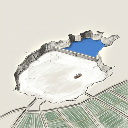
The contraction accelerated throughout the nineteen eighties. In nineteen eighty-nine, the falling water level permanently split the sea into two distinct bodies of water: the Small Aral in the north and the Large Aral in the south. When the Soviet Union dissolved in nineteen ninety-one, the regional water management system collapsed into geopolitical division. The interconnected network of reservoirs, headwaters, and canals was suddenly divided among five independent nations, each with competing economic priorities. Upstream states like Kyrgyzstan and Tajikistan held the mountain water and wanted to release it in winter to generate hydroelectric power. Meanwhile, downstream states like Uzbekistan, Kazakhstan, and Turkmenistan needed massive water releases in summer to irrigate their crops.
As the sea lost water volume, its salt concentration surged. Within two decades, the water transitioned from brackish to hyper-saline. By the mid-nineteen eighties, salinity in the main basin climbed past thirty grams per liter, matching the open ocean, and kept rising. The native freshwater fish species could not adapt. Their eggs failed to hatch, their food webs collapsed, and within a few years, commercial fishing across the southern sea ended completely.
In Muynak, the economic foundation of the town vanished almost overnight. The water retreated so rapidly that ships were left stranded at their moorings, eventually sitting miles from the nearest damp mud. Fish-canning facilities attempted to remain open by importing frozen fish by rail from the Arctic and Baltic seas, but the logistics were unsustainable. Tens of thousands of jobs in fishing, processing, net making, and transport disappeared, triggering widespread out-migration and economic depression across the surrounding autonomous republic of Karakalpakstan.
The retreat of the Aral Sea did not leave behind benign sand. It exposed over fifty thousand square kilometers of former lakebed, creating an entirely new geographic feature known as the Aralkum Desert.
This exposed seabed is carpeted in fine silt saturated with sodium chloride, sodium sulfate, magnesium, and agricultural chemical residues carried downriver over decades of intensive cotton farming. Because the basin is flat and open to regional wind patterns, powerful storms lift this dry material into the atmosphere. Satellite sensors frequently record enormous white dust plumes blowing across hundreds of kilometers.
These dust storms deposit millions of tons of salt and particulate matter onto surrounding settlements and farmland each year. When the airborne salt settles on productive fields, it degrades soil quality and reduces crop yields, forcing farmers to use even more scarce water to flush their land. Scientists have tracked Aral dust particles as far away as the Arctic and across the high glaciers of the Pamir Mountains. There, the dark, salty dust settles on snowpack, accelerates melting, and alters long-term river replenishment.
The physical loss of the water body also fundamentally altered the local climate. Without sixty-eight thousand square kilometers of open water to moderate seasonal extremes, the regional microclimate became continental and unforgiving. Summers grew hotter, shorter, and drier, while winters grew longer and bitterly cold. The local growing season shrank, placing further economic stress on the agricultural sector that had originally consumed the water.
For the people living in communities around the former shoreline, the environmental collapse evolved into a public health crisis. Airborne dust saturated with fine particulate matter caused chronic irritation of the respiratory system, contributing to high rates of chronic bronchitis, asthma, and throat disorders. Drinking water supplies deteriorated sharply as shallow aquifers became saline and contaminated with agricultural runoff.
Epidemiological studies conducted in the region documented elevated incidences of kidney disease, liver dysfunction, digestive tract cancers, and severe nutritional deficiencies. Anemia became widespread among women and children, driven in part by poor water quality and the collapse of the local fishery, which had historically provided an affordable source of dietary protein.
Untangling the exact medical causes remains complex. Researchers have pointed out that high rates of illness cannot be attributed exclusively to airborne pesticides or a single toxic contaminant. Instead, the health profile reflects an overlapping web of environmental stressors: salty dust, degraded drinking water, poverty, declining sanitation infrastructure following the post-Soviet economic transition, and limited access to clinical healthcare.
Adding to the basin's ecological complexity was the legacy of Vozrozhdeniya Island. During the Soviet period, this remote, isolated island in the middle of the sea was used by the military for open-air testing of biological agents, including anthrax, plague, and tularemia. As the Aral Sea dried out and its water levels fell, the island expanded. In the early two-thousands, the southern channel dried up completely, turning the former island into a peninsula directly connected to the mainland.
The physical connection raised urgent concerns that wild animals or unauthorized scavengers could access historical testing sites and spread dormant pathogens. In two thousand two, a joint scientific operation between the United States and Uzbekistan neutralized several tons of buried anthrax spores on the site to reduce the immediate biological threat. While the island's military history is distinct from the broader regional health crisis, it demonstrates how the rapid draining of an inland sea produced security risks that planners never anticipated.
By the late nineteen nineties, the Aral Sea was largely considered a lost cause by international observers. But the geographic split between the northern and southern basins created an unexpected engineering opportunity.
The Small Aral Sea in the north sits at a slightly higher elevation than the massive southern basin. It is located entirely within Kazakhstan and receives the inflow of the Syr Darya. Under natural conditions, water entering the north simply spilled southward through a narrow channel called the Berg Strait, where it spread across the vast southern mudflats and evaporated under the desert sun. Because the northern basin was relatively compact, Kazakh engineers and international specialists realized that if they could physically separate the two water bodies, they could trap the Syr Darya's flow and rebuild a viable lake in the north.
Early attempts by local communities to construct temporary sand dams across the strait were repeatedly washed away by seasonal storms. But in two thousand one, the government of Kazakhstan secured financing from the World Bank to undertake a comprehensive engineering intervention known as the Syr Darya Control and Northern Aral Sea Project.
The centerpiece of this project was the Kok-Aral Dam, completed in August two thousand five. Spanning thirteen kilometers across the Berg Strait, this concrete and earthen barrier acts as a physical plug. It allows water managers to retain incoming fresh water from the Syr Darya inside the northern basin, while a concrete spillway releases excess water southward only when target water levels are achieved. Along with the dam, engineers rebuilt hydraulic gates, reinforced dikes, and cleared canal bottlenecks along the Syr Darya to ensure that water actually reached the sea rather than spilling into desert marshes upstream.
The hydrological response was dramatically faster than models predicted. Within just a few years of the dam's completion, water levels in the North Aral rose by several meters. The surface area of the northern sea expanded by hundreds of square kilometers, and the total volume of water stored behind the dam increased by sixty-eight percent.
As fresh water accumulated, it pushed down the salt concentration. Average salinity in the North Aral plummeted from roughly thirty grams per liter to approximately eight grams per liter. This drop brought salinity back below the critical physiological threshold for freshwater fish.
The ecological cascade reversed direction. Roughly twenty species of freshwater and brackish fish, which had disappeared or survived only in the Syr Darya delta lagoons, repopulated the open lake. Commercial fishing operations restarted. Official fishery records show that commercial catches in the North Aral rose from just fifty-two tons in two thousand four to roughly two thousand tons in two thousand seven, eventually climbing even higher in subsequent years.
Fish-processing plants reopened in Aralsk, processing catches of pike-perch and carp for local consumption and export to European markets. Although the water has not fully returned to the town's historical shoreline, the shoreline moved dozens of kilometers closer, dampening dust storms, reviving delta wetlands, and providing sustainable livelihoods to thousands of families. The Kok-Aral Dam proved that targeted, well-funded hydrological intervention can successfully reverse environmental collapse in a defined basin.
The dramatic success of the North Aral Sea immediately forces a difficult question: why can engineers not apply the exact same engineering playbook to save the southern sea?
The answer comes down to geometry, volume, and the economics of agriculture. The southern basin is vastly larger and deeper than the north. To refill the South Aral Sea to its historical levels would require hundreds of cubic kilometers of water, an amount that simply does not exist in the regional water budget.
The southern basin depends entirely on the Amu Darya. Unlike the Syr Darya in Kazakhstan, the Amu Darya flows through multiple countries with conflicting economic needs and rapidly growing populations. Upstream, Tajikistan relies on the river for hydroelectric energy. Downstream, Turkmenistan and Uzbekistan maintain extensive agricultural sectors that rely on the river's diversions to support millions of rural citizens.
Cotton, wheat, and fruits remain essential pillars of the Uzbek and Turkmen economies, providing primary employment, rural stability, and vital foreign exchange currency. Closing the irrigation networks to redirect the Amu Darya back into the southern sea would mean retiring millions of hectares of productive agricultural land. In human terms, it would displace millions of farmers and destabilize regional food supplies. No Central Asian government has been willing, or economically able, to pay that price to refill a dry seabed.
As a result, the South Aral Sea has continued to fragment. Its shallow eastern lobe has repeatedly dried into a vast, bone-dry salt flat, occasionally appearing as a muddy marsh after heavy mountain snowmelt, only to evaporate completely during the summer heat. The deeper western lobe along the Ustyurt Plateau remains a narrow strip of hyper-saline water, with salt concentrations exceeding one hundred grams per liter—roughly three times saltier than the ocean. In that environment, vertebrate life cannot survive, leaving only brine shrimp and specialized bacteria.
Faced with this permanent reality, environmental management in the south has shifted away from refilling the lake toward damage containment. Uzbekistan and international organizations have focused on planting millions of drought-resistant, salt-tolerant shrubs, such as black saxaul, across the exposed seabed of the Aralkum Desert. These hardy plants develop deep root systems that anchor the loose sediment, helping to prevent dust storms and reduce airborne salt drift. Downstream engineering has also concentrated on stabilizing residual wetland lakes within the Amu Darya delta, preserving critical wildlife habitats and local fisheries without attempting to refill the entire sea.
This stark contrast between north and south reveals that environmental recovery is rarely an all-or-nothing proposition. Recovery is measured across multiple indicators: water volume, salinity levels, delta wetland health, dust exposure, drinking water safety, and economic security. In Kazakhstan, a disciplined decision to sacrifice the vast southern basin made it possible to save the north. In Uzbekistan, managing the social and economic consequences of the dry seabed has taken precedence over hydrological restoration.
The fate of the Aral Sea remains the modern world's clearest demonstration of a fundamental rule: you cannot withdraw water from a closed hydrological cycle without paying an ecological debt somewhere downstream. As changing mountain snowpack and rising global temperatures put pressure on terminal lakes worldwide, the lesson of the Aral is that when human choices disrupt the balance of an inland basin, repairing even a fraction of the damage requires extraordinary political will, precise engineering, and compromises that last for generations.
As you reflect on the trade-offs that drained an inland sea and saved only one of its basins, consider the water systems that support your own daily life. Whose upstream choices are determining what arrives at your end of the river? If this account gave you a new perspective on how human policy reshapes the earth, explore our library for more deep dives into the hidden histories of our changing planet.