Moving the Cape Hatteras Lighthouse: Engineering a Historic Retreat from the Atlantic
In 1999, engineers rescued the Cape Hatteras Lighthouse from an eroding shoreline by lifting the nearly 5,000-ton brick tower onto a steel cradle and moving it 2,900 feet inland over 23 carefully monitored days. The move preserved the lighthouse and its historic station, but left its original site behind—a striking example of what it takes to protect a landmark when the coastline itself keeps moving.
By MyAudioBooks.ai ·
Listen free: Moving the Cape Hatteras Lighthouse: Engineering a Historic Retreat from the Atlantic
In the summer of nineteen ninety-nine, an enormous brick tower weighing nearly five thousand tons began crawling across the sand of North Carolina's Outer Banks. Built one hundred twenty-nine years earlier and standing almost two hundred feet tall, the Cape Hatteras Lighthouse was never engineered to move. Yet there it was, lifted off its timber foundation, sliding across steel beams at a pace measured in feet per hour, traveling away from an encroaching Atlantic Ocean. The central question facing the engineers was audacious. How could they pick up an unreinforced masonry monument, transport it more than half a mile across shifting sand, and set it down without cracking the mortar, tipping the tower, or shattering it to pieces?
At My Audio Books dot A I, you can create your own audiobooks from prompts, turn your documents into audio, all with one subscription, and store your items in your own personal library.
In eighteen seventy, construction crews completed the tallest brick lighthouse in the United States. Rising one hundred ninety-eight feet above the coast, the present Cape Hatteras Lighthouse replaced an eighteen-oh-three stone tower whose modest height of roughly sixty-eight feet and dim oil lamps had proved dangerously inadequate for passing ships. To make the new beacon recognizable to sailors during daylight hours, painters coated the exterior in a bold black-and-white spiral pattern, creating an unmistakable daytime marker against the Atlantic sky.
The tower anchored an entire maritime compound of seven historic structures, including two keeper residences, brick cisterns for fresh water, and a dedicated oil house. For generations, keepers tended the giant glass lens, relying on this self-contained station to warn maritime traffic away from Diamond Shoals, an expanse of shifting underwater sandbars known as the Graveyard of the Atlantic.
When workers finished the lighthouse in eighteen seventy, they set the base on a subterranean mat of massive yellow pine timbers. Because this wood rested below the permanent freshwater table, it remained shielded from oxygen and natural decay, providing a remarkably durable footing for over a century. That foundation, however, relied entirely on the surrounding sand staying stable and saturated.
The Outer Banks are barrier islands, long and narrow ribbons of sand exposed to the open ocean. These landforms possess no bedrock anchor. Ocean waves, longshore currents, and frequent storm surges continually redistribute sand, eroding beaches in one area while building shoals in another. During violent coastal storms, seawater washes entirely across the low-lying island, flattening protective dunes and pushing the barrier shoreline westward toward the mainland.
When the lighthouse was first illuminated, the Atlantic surf broke roughly fifteen hundred feet away. Over the following century, the dynamic shoreline steadily retreated. By the late twentieth century, coastal surveys showed the high-water line creeping within roughly one hundred twenty to one hundred fifty feet of the base, depending on the season and prevailing tides.
The reality of this loss became unmistakable in March nineteen eighty, when a severe winter storm battered the cape, wiping out oceanfront dunes and sweeping away the remaining foundation ruins of the original eighteen-oh-three lighthouse. If shoreline erosion stripped the supporting sand from beneath the eighteen seventy tower, the yellow pine timbers would be exposed to air, rot, and wave scour. The National Park Service, which had administered the Cape Hatteras National Seashore since the nineteen thirties, faced an urgent preservation choice: defend the historic site, dismantle the landmark, accept its eventual collapse into the sea, or find a way to move it.
Preserving the lighthouse triggered years of debate among engineers, geologists, and coastal communities. Every proposed path involved significant engineering, financial, and philosophical tradeoffs.
Leaving the tower in place preserved its exact historic geography, but it left the masonry exposed to severe storms and potential foundation failure. To defend the original site, engineers considered surrounding the tower with hard shoreline structures like heavy rock revetments, massive seawalls, or offshore groins designed to trap moving sand. Over several decades, emergency sandbags, sheet-pile bulkheads, and groins had already been installed near the point.
Yet hard structures alter natural coastal currents. They often cause deeper underwater scouring in front of the barrier and starve neighboring beaches of sand through interrupted littoral drift. Maintaining these defenses against open-ocean hurricanes required constant, expensive maintenance. Furthermore, an armored concrete wall would permanently sever the lighthouse from its open-beach environment, turning a historic maritime landmark into a fortified fortress.
A second option proposed dismantling the tower brick by brick and reconstructing it safely inland. While dismantling simplified the transportation process, taking apart nineteenth-century masonry posed extreme conservation risks. The historic lime mortar bonded tightly to the original soft brick. Prying millions of bricks apart would cause extensive surface damage, require modern replacement materials, and destroy the continuous structural integrity of the original tower.
A third alternative involved relocating the entire historic station intact. Moving the tower southwest along the island would rescue the original masonry while keeping the complex together. Transporting the keeper residences, the oil house, and the cisterns alongside the tower ensured the station preserved the spatial relationships that defined its operational history.
The adopted route carried the tower twenty-nine hundred feet to the southwest, a little over half a mile inland. This destination placed the lighthouse approximately fifteen hundred feet from the modern shoreline, restoring roughly the same protective buffer it enjoyed when first illuminated in eighteen seventy.
The National Park Service reported an overall project cost of approximately eleven point eight million dollars. Contemporary news coverage sometimes cited preliminary estimates near ten million dollars, reflecting early contract phases rather than competing accounting totals. The decision prioritized the complete physical survival of the tower and its compound, betting millions of dollars that modern structural engineering could transport brittle nineteenth-century brick across shifting sand.
Before the lighthouse traveled a single foot, more than a year of intensive preparation took place at the site. The engineering team had to evaluate the internal strength of the tower, prepare a firm travel corridor, and pour an enormous concrete foundation at the destination.
The central engineering challenge stemmed from the physical properties of brick. Masonry excels at carrying compressive loads, meaning it can support immense weight pressing straight down. It possesses almost no tensile strength. If a masonry structure bends, twists, or stretches unevenly, the mortar joints pull apart and severe structural cracks quickly develop.
The height of the lighthouse made even support an absolute necessity. The tower tapers upward, resting on an octagonal brick base with walls twelve feet thick that thin to roughly three feet thick near the lantern room. Because of this broad, heavy lower section, the tower's center of gravity sits relatively low, roughly one-third of the way up the shaft.
Even so, any uneven settling during transport would tilt the tower sideways. Tilting shifts the center of gravity away from the vertical axis, multiplying lateral forces and rapidly increasing the risk of an overturn. Keeping the tower rigidly vertical was an uncompromising structural mandate.
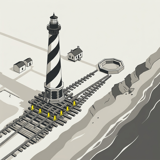
To support the nearly five-thousand-ton structure, contractors carefully excavated around the base down to its historic foundation. Workers systematically cut horizontal slots through the granite and brick base, replacing portions of stone with temporary shoring timbers and heavy steel needle beams.
Gradually, crews assembled a crisscrossed grid of steel beneath the entire circumference of the tower. This transport frame contained roughly four hundred tons of structural steel. It acted as an artificial structural cradle, distributing the immense weight across wide steel beams rather than concentrating stress on individual sections of fragile masonry.
Hydraulic jacks built directly into the steel beam network then lifted the tower off its original wood foundation. By pumping pressurized fluid into sealed cylinders, operators exerted controlled, uniform lifting force. The jacks slowly hoisted the entire four-thousand-eight-hundred-ton masonry mass about six feet into the air, creating the clearance required to slip heavy rolling equipment underneath. The governing engineering principle remained constant throughout: continuous, uniform support. The tower possessed sufficient strength to hold its own weight, provided every square foot of its base moved at the exact same elevation.
On June seventeenth, nineteen ninety-nine, the principal move began. Beneath the main steel cradle, crews laid parallel lines of steel track beams to serve as rigid rails. Riding atop these tracks were specialized roller assemblies. Engineering documentation from North Carolina State University describes approximately one hundred guided steel rollers operating beneath the cradle during the final movement phase, each designed to spread dozens of tons across the hardened steel beams.
To ensure the tower remained level while traveling, engineers organized the vertical hydraulic jacks into three independent support zones. This three-zone hydraulic system functioned like a three-legged stool, which inherently maintains stable contact on irregular surfaces without rocking.
Automated sensors continuously checked hydraulic pressure and structural tilt. If the ground settled slightly under one rail, operators adjusted fluid pressure in that specific zone to restore balance before any strain reached the brickwork.
Horizontal hydraulic push jacks anchored to the track beams behind the cradle drove the tower forward. Under high hydraulic pressure, these rams extended slowly, pushing the steel cradle and its cargo across the rollers. Each push cycle advanced the tower forward about five feet.
Once the jacks fully extended, the movement halted. Technicians inspected the entire framework, verified tilt readings, and confirmed that the masonry showed no evidence of stress. Workers then retracted the hydraulic push cylinders, pinned them to the next anchor points on the track beams, and retrieved the steel roller assemblies rolling out the back to place them ahead of the cradle.
This sequence created a methodical rhythm: push five feet, inspect stability, reset equipment, and push again. The popular phrase inch by inch captured the extreme caution of the crew, but the operating cycle relied on decisive advances of roughly five feet separated by hours of meticulous setup.
The journey lasted twenty-three days, moving along a cleared corridor of maritime forest and dunes until the tower reached its destination on July ninth, nineteen ninety-nine. Covering twenty-nine hundred feet over twenty-three days yielded an average pace of roughly one hundred twenty-six feet per day. That average reflected the extensive time spent inspecting, measuring, and resetting equipment rather than the forward velocity of an individual hydraulic stroke.
At the destination, workers completed a thick concrete foundation mat anchored deep into the ground. Hydraulic jacks gently lowered the tower onto its new base, transferring the weight off the temporary steel framework. Crews then relocated the keeper residences, the oil house, and the cisterns, placing them in their historic arrangement and maintaining their original orientation toward the ocean.
The relocation of the Cape Hatteras Lighthouse preserved the material fabric of the monument: its nineteenth-century brickwork, its recognizable daymark spiral, and the physical relationships uniting the historic compound. The new site recreated an approximate fifteen-hundred-foot buffer from the Atlantic surf, giving the station breathing room from routine wave action.
Yet moving a landmark forces a fundamental shift in what historic preservation protects. Historic authenticity involves several distinct dimensions: original physical materials, original construction methods, visual setting, and historic location. Relocation preserved the materials and the architectural layout, but the exact historic location remained behind. The tower separated from its original foundation timbers, its subsurface archaeological context, and its historic connection to that specific patch of shore.
Coastal planners and environmental agencies often cite the Cape Hatteras move as a prominent case study in managed retreat: moving valuable infrastructure away from hazard zones rather than attempting to hold migrating shorelines permanently in place. Managed retreat acknowledges the natural mobility of coastal landforms. The barrier islands of North Carolina are dynamic systems that reshape their shorelines in response to sea-level shifts and powerful storms.
Relocating the tower reset the clock rather than halting the coastal processes themselves. Storm tides, wind, and longshore currents continue to move sand along the cape, meaning the shoreline will eventually narrow the fifteen-hundred-foot buffer once again.
Relocation also does not offer a universal answer for coastal heritage. The Cape Hatteras project succeeded because of a rare alignment of circumstances: an exceptionally strong, symmetrical masonry structure, an accessible inland corridor within a national park, advanced heavy-moving engineering, and millions of dollars in federal funding. For thousands of historic coastal sites, maritime neighborhoods, and vulnerable archaeological deposits, mechanical relocation is neither structurally possible nor financially viable.
The move leaves lingering questions for coastal heritage management. As sea levels and coastal storms place increasing pressure on shoreline landmarks, societies face difficult choices about which places justify complex technical rescues, which should be protected with short-term defenses, and which must eventually be yielded to the sea.
The Cape Hatteras Lighthouse survived its journey because engineers respected the fragility of its brickwork, distributed its weight, and measured every advance with care. Preserving the past does not require pretending the ground beneath our feet is motionless. When shifting coasts threaten our most valued landmarks, deciding what can move, what can only be defended, and what will ultimately be lost remains the central question of modern preservation. If you want to explore more remarkable intersections of engineering and history, stay with us as we investigate how human ingenuity confronts the forces of a changing world.