Fossil Water Beneath the Desert: Ancient Aquifers and Modern Pumping in North Africa and Arabia
Beneath the Sahara and Arabian Peninsula, vast aquifers hold rain that fell when today’s deserts were green. For centuries, gravity-fed tunnels helped sustain oases, but modern pumps now draw down these ancient reserves far faster than they can recharge, threatening water quality and future supplies. The challenge is to govern this shared inheritance without mistaking access for renewal.
By MyAudioBooks.ai ·
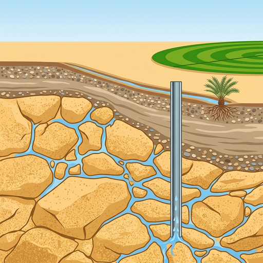
Beneath the sands of the Sahara and the gravel plains of the Arabian Peninsula lies an ocean of freshwater that the modern sky could never produce. Every day, center-pivot fields, desert towns, and expanding cities pump millions of liters from deep underground, sustaining life in landscapes that receive only a few millimeters of rain each year. This water is not an active circulation of modern weather. It is a buried inheritance from vanished pluvial eras, preserved in bedrock from times when these deserts were green. In the minutes ahead, we will explore where this ancient water came from, how human societies tapped it for centuries through gravity without depleting the source, and what happens when motorized extraction spends thousands of years of geological savings in a matter of decades.
At My Audio Books dot A I, you can create your own audiobooks from prompts, turn your documents into audio, all with one subscription, and store your items in your own personal library.
To understand where this water rests, you have to discard the mental image of subterranean lakes or open underground caverns. In almost every major desert system, groundwater sits trapped within microscopic pores, tiny fissures, and interconnected fractures inside solid rock and compacted sediment. An aquifer is a geological formation of porous sandstone, fractured limestone, or gravel that has both the storage capacity to hold water and the permeability to transmit it at usable rates.
These rock formations are often separated by confining beds—dense, low-permeability layers of clay, shale, or siltstone that restrict the vertical movement of fluid. Where an aquifer is unconfined, its upper boundary is the water table, open to whatever rainfall manages to soak past the root zone. Where an aquifer is confined beneath thick, impermeable rock, the trapped groundwater remains isolated from rapid surface changes for thousands of years, held under natural hydraulic pressure.
This architecture creates a fundamental distinction between renewable and fossil groundwater. Renewable groundwater receives continuous replenishment on timescales relevant to human planning, refilling as modern rain infiltrates downward. Fossil groundwater, by contrast, accumulated under past climatic regimes that no longer exist. Today, recharge in these hyper-arid zones is near zero, or confined to small, episodic events. Calling an aquifer fossil does not mean every single molecule is ancient, nor does it mean the water has turned to stone. The term describes an aquifer whose dominant volume was charged during an ancient era. Modern withdrawals are taking from a static reserve rather than a circulating current.
These reserves are not a single, continuous subterranean ocean stretching across continents. Instead, they form discrete, regionally bounded geological basins, each with its own depth, mineral chemistry, and hydrological behavior. Across northeast Africa lies the Nubian Sandstone Aquifer System, spanning more than two million square kilometers beneath parts of Egypt, Libya, Sudan, and Chad. It is one of the largest accumulations of fossil water on Earth, composed of massive, multi-layered sandstone formations that reach several kilometers in thickness in deep structural troughs.
Further west lies the North Western Sahara Aquifer System, underlying Algeria, Tunisia, and Libya, comprising continental sands and marine carbonates. Eastward across the Red Sea, the Arabian Peninsula holds its own sequence of deep aquifers, including the Saq Sandstone, the Wasia-Biyadh-Mishrif carbonate complex, and the Minjur system. Each of these reservoirs behaves differently. Some contain fresh, potable water deposited during cool pluvial regimes; others contain brackish water modified by dissolved rock salts or stagnant circulation over millions of years.
For centuries, human survival across these arid zones depended on natural springs and shallow wells that reached the margins of these systems, feeding date palms, caravan posts, and isolated oases. Today, however, these same deep formations supply extensive irrigated agriculture, industrial complexes, and rapidly growing urban populations. Water emerging from a modern wellhead carries no visible date stamp. To understand the true longevity of this resource, hydrologists had to find a way to read the calendar encoded within the water itself.
The origin of this water belongs to the Pleistocene and early Holocene epochs, geological intervals marked by dramatic swings in global climate. Between ten thousand and five thousand years ago, and during several longer wet phases stretching back hundreds of thousands of years, orbital variations shifted the monsoon belts northward. Storm tracks from the Atlantic and Mediterranean pushed deep into continental interiors that are now bone-dry. The Sahara and the Arabian interior were dotted with vast freshwater lakes, meandering rivers, savanna grasslands, and dense woodlands.
During these pluvial episodes, intense and sustained rainfall soaked through permeable soils, escaped evaporation, and percolated past the root zones of deep vegetation. Gravity pulled this water downward into the regional bedrock, filling interconnected pores and recharging deep sandstone and limestone strata. As the climate shifted toward hyper-aridity over thousands of years, the surface lakes evaporated and vegetation receded, leaving behind the modern desert. The water that had reached deep, confined strata remained trapped, insulated by impermeable caprocks from surface evaporation.
Scientists reconstruct this timeline using environmental isotopes—forms of an element with different atomic weights. Water molecules are composed of hydrogen and oxygen, both of which exist in heavy and light varieties. Water containing lighter isotopes evaporates more readily, while heavier isotopes condense and fall first as rain. Because temperature, distance from the ocean, and storm dynamics dictate isotope ratios, the water trapped inside an aquifer preserves a distinct fingerprint of the weather conditions that produced the original rainstorm. When researchers sample deep Saharan groundwater, they routinely find depleted isotope values that reflect cool, high-latitude or intense paleomonsoon rainfall, entirely distinct from the rare, highly evaporated rains of the modern desert.
To determine how long that water has been underground, hydrologists turn to radioactive tracers. Naturally occurring carbon fourteen, absorbed from the atmosphere into ancient rainwater as dissolved inorganic carbon, decays with a known half-life of five thousand seven hundred thirty years. By measuring the remaining carbon fourteen in deep groundwater, hydrologists can date water up to approximately thirty thousand or forty thousand years old. For water that is far older, researchers use chlorine thirty-six, a cosmogenic isotope with a half-life of roughly three hundred thousand years, capable of tracing water that infiltrated hundreds of thousands of years ago.
Modern nuclear weapons testing in the twentieth century introduced a pulse of tritium into the atmosphere, allowing hydrologists to detect whether ancient water is mixing with any rain that fell after nineteen fifty-two. Furthermore, noble gases like neon, argon, krypton, and xenon dissolve in groundwater in direct proportion to the ground temperature at the time of infiltration. By measuring noble gas concentrations, scientists can calculate the ground temperature of the Sahara during the last ice age. These isotopic tools do not produce simple calendar dates stamped on a single drop; mineral dissolution and subsurface mixing require careful geochemical modeling. Yet together, they provide clear, verifiable evidence that the vast majority of this water fell under skies that vanished thousands of years ago.
Before the invention of internal combustion engines and electric turbine pumps, desert societies developed sophisticated civil engineering to access groundwater without draining their source. The most famous of these structures are gently sloping underground tunnels known as qanats in Iran and Arabia, foggaras in North Africa, and karez across Central Asia. While these regional systems feature distinct local masonry and social traditions, they operate on a shared physical principle: harnessing gravity to tap an alluvial water table upslope and channel it underground to arid lowlands.
Engineers dug a mother well into an alluvial fan or elevated aquifer, then excavated a horizontal gallery with a very gentle downward slope—often less than one meter of descent for every thousand meters of distance. Vertical shafts were sunk every few dozen meters to remove spoil, provide ventilation, and allow maintenance. Because the gallery traveled underground, the water was protected from the intense desert heat and scorching winds, preventing evaporative loss. When the tunnel emerged onto agricultural land, it discharged continuous, gravity-fed water directly into irrigation ditches and settlement cisterns.
These traditional galleries possessed a built-in ecological constraint. The volume of water a foggara delivered was governed entirely by the height of the local water table and the permeability of the rock. If a prolonged dry spell lowered the water table, the gallery discharge naturally slowed or ceased. The engineering respected the water table because it was physically incapable of pulling water upward from below its tunnel floor. For centuries, this mechanism sustained self-balancing oasis economies, supporting date palms, wheat plots, and caravan trade networks across the hyper-arid belts of North Africa and the Middle East.
The arrival of modern mechanical drilling and deep submersible pumps shattered that physical constraint. Beginning in the mid-twentieth century, diesel and electric pumps allowed farmers and state agencies to sink steel-cased boreholes hundreds of meters past shallow aquifers into deep, confined formations. Instead of waiting for water to emerge by gravity, motorized impellers pulled water to the surface under massive suction and pressure. As deep pumping expanded across agricultural basins, regional water tables plunged. Thousands of ancient foggaras and qanats, though structurally intact, dried up completely as the water table dropped well below their collection channels. Mechanization substituted energy for hydraulic equilibrium, transforming a steady, natural yield into an industrial extraction campaign.
When groundwater withdrawal consistently outpaces natural replenishment, the physical consequences extend far beyond a lowering of the water level. In confined aquifers, high initial hydraulic pressure can push water upward in a wellbore toward the surface, an effect known as artesian flow. As heavy pumping extracts millions of cubic meters, that pore pressure drops rapidly. The water must then be lifted mechanically from ever-greater depths, demanding increasingly expensive energy inputs. In fine-grained, compressible silt or clay formations, the loss of fluid pressure allows the rock skeleton to collapse, leading to permanent land subsidence and an irreversible loss of underground storage capacity. In coastal or saline basins, deep cones of depression reverse regional gradients, drawing underlying saline water or seawater into freshwater wells.
The scale of modern extraction is illustrated by two prominent regional examples. In Libya, the Great Man-Made River represents one of the largest civil engineering projects in modern history. It consists of a network of massive, four-meter-wide buried concrete pipes spanning thousands of kilometers across the desert. The system pumps fossil water from hundreds of deep boreholes in the southern Kufra and Sarir basins, transporting billions of liters daily northward to coastal cities like Tripoli and Benghazi. While this infrastructure supplies drinking water and irrigation to millions of citizens who have virtually no surface rivers, it functions hydrologically as an extractive pipeline. Moving water hundreds of kilometers across the desert does nothing to refill the southern sandstone formations from which it is mined.
An equally dramatic transformation occurred across the Arabian Peninsula. Driven by national policies to achieve agricultural self-sufficiency in wheat, dairy, and animal feed, deep drilling expanded rapidly across Saudi Arabia starting in the late twentieth century. In hyper-arid basins, thousands of center-pivot irrigation systems carved bright green circles of alfalfa and grain into the bare desert floor. Hydrogeological assessments demonstrate the profound imbalance of this production. Regional evaluations of the Saq and associated deep aquifers estimated extraction at roughly twenty billion cubic meters annually, compared to an estimated annual modern recharge of just two point four billion cubic meters. That means approximately eight units of water are withdrawn for every single unit replenished.
In other formations, the disparity is even starker. A study examining the Minjur Aquifer System calculated that local extraction rates reached roughly one hundred times the volume of modern recharge. Because different aquifers feature distinct boundary conditions, structural faulting, and water chemistry, these ratios cannot be applied as a single uniform figure across the entire peninsula. Yet whether the extraction-to-recharge ratio is eight to one or one hundred to one, the underlying arithmetic remains the same: human society is mining a non-renewable geological deposit.
The regional footprint of this extraction is measurable from space. Between April two thousand two and July two thousand sixteen, the Gravity Recovery and Climate Experiment satellite mission monitored shifts in Earth's gravitational field caused by changes in water mass on land. Across the Arabian Peninsula, satellite data recorded an average annual mass loss equivalent to five point three millimeters of water thickness distributed across the study area each year. This satellite signal captures the combined loss of soil moisture, surface storage, and groundwater. When hydrologists calibrate this gravity data with ground-based observation wells and hydrological modeling, they confirm that deep groundwater mining accounts for the overwhelming majority of that missing mass.
Recognizing groundwater as an inheritance does not mean that every drop of modern rain is lost. Contemporary recharge does occur in arid lands: flash floods sweep down ephemeral wadis, episodic storms infiltrate alluvial gravels at mountain fronts, and excess irrigation water percolates back into shallow strata. Yet in the deep, regional sandstone and carbonate aquifers that anchor national water budgets, these contemporary inputs remain a tiny fraction of the total extraction volume. Depleting this water is not merely spending a recurring dividend; it is liquidating geological capital accumulated over tens of thousands of years.
Furthermore, the total volume of water stored inside rock is never the same as the volume that can actually be recovered. As an aquifer is drawn down, declining pore pressure, increasing well interference, and deteriorating water quality impose hard physical and economic boundaries. Deep groundwater is frequently stratified: older, fresher water may sit directly above or adjacent to ancient, hyper-saline brines. Over-pumping can pull these brines into production zones, rendering the water unusable for crops or municipal taps long before the physical pore space runs dry. Lifting water from depths of several hundred meters also requires continuous energy, tying the cost of water directly to the price of fuel and electricity.
These hydrogeological realities are further complicated by international borders. The Nubian Sandstone Aquifer System lies beneath Egypt, Libya, Sudan, and Chad. Groundwater obeys hydraulic pressure gradients, not political treaties. Heavy pumping in a well field in southeastern Libya or western Egypt can create regional drawdown cones that propagate outward across national boundaries over decades, lowering water levels in neighboring countries. To address this risk, the four nations established a joint authority and collaborated on three-dimensional numerical flow models, supported by shared isotopic mapping, to monitor transboundary impacts. Managing a shared subterranean basin requires regional coordination, because no single nation can isolate its portion of the rock from the physics of flow.
In response to declining storage, governments across North Africa and the Middle East are shifting strategies. Saudi Arabia phased out subsidies for water-intensive wheat and forage crops, seeking to halt the rapid depletion of deep reserves, while expanding coastal seawater desalination and wastewater recycling to meet urban demand. Desalination and water reuse provide critical alternatives, yet they do not magically refill the deep sandstone reservoirs. Instead, they slow the rate at which the remaining inheritance is exhausted.
Several crucial questions remain open for hydrologists and policymakers. How much of the water emerging from each producing well field represents genuinely ancient water, and how much is modern leakage? Exactly how much recharge penetrates deep aquifers during rare, extreme storm events? And most urgently, what rate of depletion is acceptable when current agricultural security and urban livelihoods compete directly with the water security of future generations?
The engineering that unlocks deep fossil water is a triumph of modern technology, but access must never be confused with renewal. When you look across an arid desert sustaining green fields and bustling cities, you are looking at the climate of the ice age made visible. As we navigate a warmer and more volatile century, the central challenge is not finding new ways to drain these ancient vaults, but learning how to govern an inheritance that will not be replenished in our time.